DJI Mavic 3 Enterprise
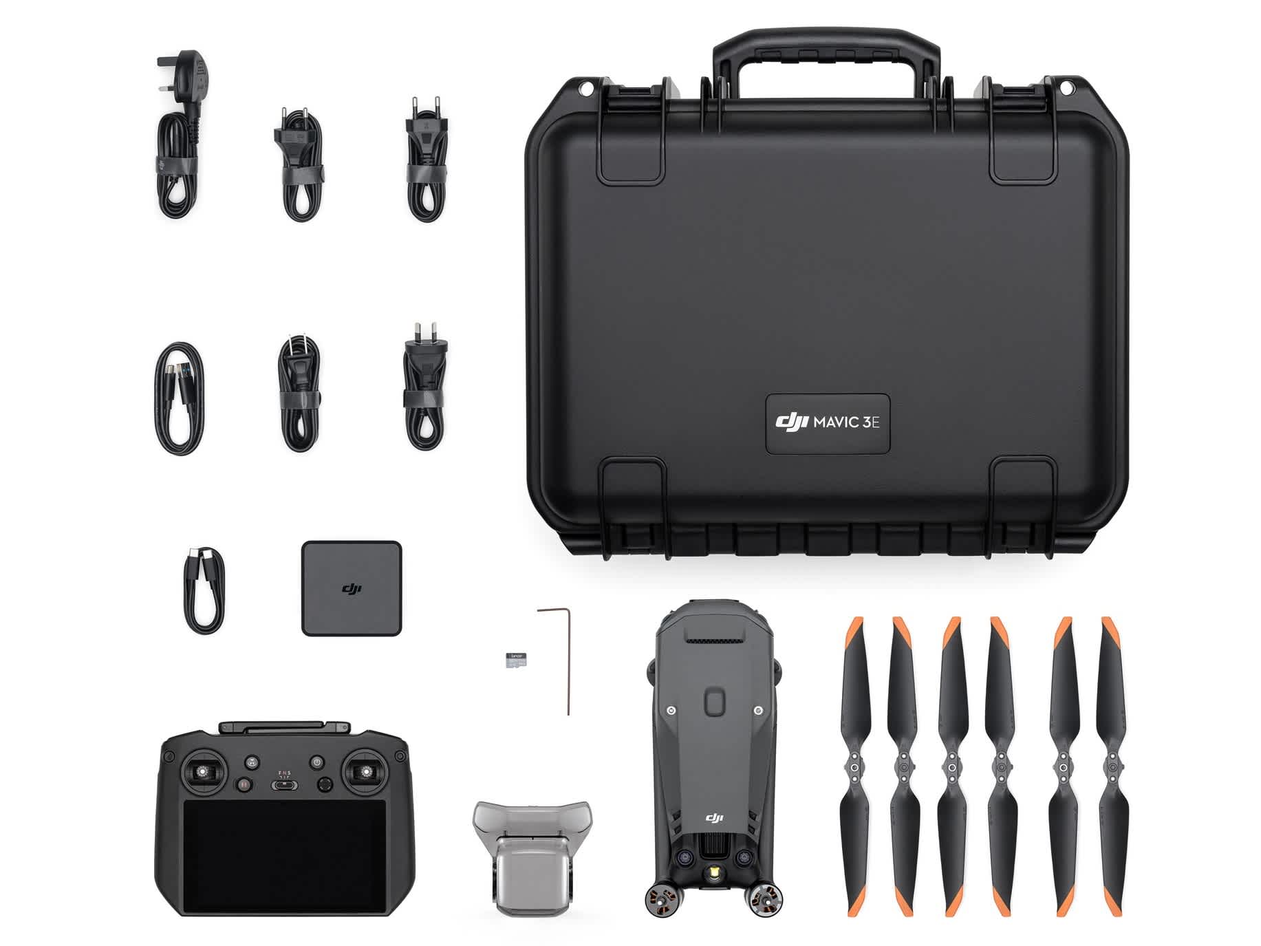
Detail Produk
-
Mavic 3 Enterprise x 1
-
Flight Battery x 1
-
SD card x 1
-
Gimbal cover x 1
-
Propeller (pairs) x 3
-
DJI RC Pro Enterprise x 1
-
Standard charger (100W) x 1
-
Power Cable x 1
-
USB-C Cable x 1
-
USB-C to USB-C Cable x 1
-
Carrying Case x 1
DJI Mavic 3 Enterprise Key Features
High-precision surveying drone
-
Optimised for precision drone surveying, with a 20MP 4/3 CMOS wide camera with mechanical shutter and large pixel size.
-
Also features a 12MP tele camera with 56x hybrid zoom - ideal for inspection.
-
Lightweight, compact, and portable: 915g airframe
-
Up to 45 minutes of flight time, or 42 minutes with RTK Module.
-
Omnidirectional obstacle sensing and advanced Return to Home.
-
Compatible with the new DJI RC Pro Enterprise smart controller, with high-bright screen.
-
Accessories (available separately) include RTK Module for centimetre-level precision; Loudspeaker; and D-RTK 2 Mobile Station high-precision GNSS receiver.
-
Deploy with DJI Pilot 2, DJI FlightHub 2, and DJI Terra software platforms.
-
The price point and size make the DJI Mavic 3 Enterprise an ideal entry-level surveying drone.
Powerful Payload For Precision Surveying
Dual camera
Equipped with wide and Tele cameras, deploy DJI Mavic 3 Enterprise for aerial surveying and precision inspection.
Its large pixel size and Intelligent Low-Light Mode offer improved performance in dim conditions.
Wide Camera
-
4/3 CMOS sensor, 20MP.
-
Large pixel size (3.3um) and 0.7s shooting interval increase surveying efficiency.
-
Mechanical shutter prevents motion blur and ensures no jelly effect under high-speed movement.
-
Equivalent focal length: 24mm.
Tele Camera
-
½ inch CMOS, 12MP.
-
162mm Equivalent Focal Length.
-
Up to 56x hybrid zoom.
Efficient Drone Mapping Solution
More data in a single flight
Spend less time surveying your job site. The Mavic 3 Enterprise's upgraded camera, along with its flight time of 45 minutes, make it an efficient surveying drone.
The Mavic 3 Enterprise is up to 8 times more efficient than DJI's other compact survey solution, the DJI Phantom 4 RTK, with 1cm GSD).
With a 5cm GSD, the orthophoto efficiency of the Mavic 3 Enterprise can reach 2.25km² - almost 2 times that of the DJI Phantom 4 RTK,
Fast-charge batteries with the 100W charging hub to ensure operational continuity.
Lightweight And Portable
Compact drone survey solution
DJI Mavic 3 Enterprise is a lightweight and integrated drone surveying solution, weighing 915g.
The compact and foldable design enables easier transportation and fast deployments for greater flexibility.
Next-gen Safety Features
Greater peace of mind during flights
-
DJI APAS System 5.0: Equipped with wide-angle lenses on all sides and APAS 5.0 for omnidirectional obstacle avoidance with zero blind spots.
-
DJI 03 Enterprise Transmission: Benefit from a maximum control range of 8km (CE) and stable transmission signals with a 1080p/30fps live feed.
-
DJI AirSense: Receive ADS-B signals from traditional aircraft for greater airspace awareness.
-
Advanced RTH: The drone automatically determines the optimal route back to its home point and executes it quickly.
Robust Data Security
Keep your sensitive data safe
State-of-the-art security features protect the integrity of photos, videos, flight logs and other data generated during sensitive flight.
-
Local Data Mode: When activated, Local Data Mode stops the DJI Pilot 2 flight control app from sending or receiving data over the internet.
-
AES-256 Encryption: The radio link between the aircraft and remote controller features robust AES-256 encryption, ensuring critical information exchanged between the drone and its remote is protected.
Accessory Ecosystem
Expansion options
-
DJI RC Pro: The new DJI RC Pro enterprise controller comes with the DJI Mavic 3 Enterprise as standard. This smart controller has a 5.5-inch, 1,000-nit high-bright screen, 3 hours of battery life, and enhanced CPU/GPU performance,
-
RTK Module: Achieve centimetre-level accuracy with support for network RTK, custom network RTK services, and D-RTK 2 Mobile Station.
-
D-RTK 2 Mobile Station: DJI’s upgraded high-precision GNSS receiver supports all major global satellite navigation systems, providing real-time differential corrections.
-
Loud Speaker: Broadcast a message from above, with support for text-to-speech, audio storage, and looping.
The RTK Module, D-RTK 2 base station, and Loud Speaker are available separately.
light Control And Data Processing
End-to-end workflows
DJI Mavic 3 Enterprise is compatible with powerful software to empower end-to-end workflows.
-
DJI Pilot 2: Features a revamped Enterprise flight interface designed to improve piloting efficiency and flight safety. Drone and payload controls can be easily accessed with one tap.
-
DJI FlightHub 2: All-in-one cloud drone operations platform for route planning, mission management, and data centralisation.
-
DJI Terra: Mapping software for all stages of work, from mission planning to processing of 2D and 3D models. Or upload data to third-party platforms, such as Pix4D, DroneDeploy, or Esri SiteScan.